


0 reviews
Be the first to review this item!

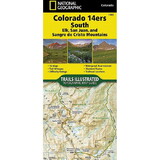
The northern New Mexico town of Taos lies in the high desert bounded by the Sangre de Cristo Mountains. In those mountains northeast of the town, Wheeler Peak rises, the highest natural point in New Mexico. Expertly researched and created in partnership with local land management agencies, National Geographic's Trails Illustrated map of Taos, Wheeler Peak provides an unparalleled tool for exploring this unique region of historic pueblos, scenic rivers, enchanting desert, and picturesque mountains. Some of the many key areas of interest included are Carson National Forest; RioGrande Del Norte National Monument; portions of Rio Honda and Red River; Coyote Creek State Park; Wheeler Peak and Latir Peak wilderness areas; Eagle Nest Lake State Park; Colin Neblett State Wildlife Area; and Taos Pueblo, a UNESCO World Heritage Site.
The Wild Rivers and Enchanted Circle scenic byways are noted for those wishing to take inthe scenery by car. Recreation features are clearly marked, including campgrounds, trailheads, interpretive trails, fishing areas, boat ramps, whitewater access, horse camps, and ski areas. The map base includes contour lines andelevations for summits, passes and lakes.
Other features found on this map include: Agua Fria Peak, Baldy Mountain, Carson National Forest, Cerro Vista, Eagle Nest Lake, Latir Peak Wilderness, Palo Flechado Pass, Wheeler Peak, Wheeler Peak Wilderness.
 Attention CA Residents: Prop 65 Warning
WARNING:
This product can expose you to chemicals which are known to the State of California to cause cancer, birth defects, or other reproductive harm. For more information, go to www.p65warnings.ca.gov.