


4 out of 5

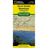
National Geographic 603244 Clingmans Dome Cataloochee Great Smoky Mtns Np No.317
* Click "Add to Shopping List" to save the item for later purchase. You can receive a notice email when it is back in stock.
Product Description
America's most visited national park and a UNESCO World Heritage Site, Great Smoky Mountains National Park is both renowned for its diversity of plant and animal life and rich in remnants of Southern Appalachian mountain culture. National Geographic's Trails Illustrated map of Clingmans Dome and Cataloochee, covers the eastern part of the park, from Sugarlands Visitor Center to the eastern boundary of the park with Pisgah National Forest. Created in partnership with the National Park Service and others, the map combines unparalleled detail and valuable information for outdoor enthusiasts seeking to explore all the area has to offer with particular attention shown to backcountry campsites, shelters, and stream crossings. The map features many key points of interest as well, including Mount Le Conte, Balsam Mountain, Roaring Fork and Newfound Gap.
The map also includes lists of backcountry campsites and shelters along with their location, elevation and capacity. A detailed profile of the Appalachian National Scenic Trail, which snakes along the ridge of the Great Smoky Mountains, provides a handy tool for hikers. Some of the many recreation features include: visitor centers, campgrounds, trail shelters, trailheads, boat ramps, scenic overlooks, waterfalls, lookout towers, interpretive trails and quiet walkways.
Other features found on this map include: Clingmans Dome, Great Smoky Mountains, Mount Chapman, Mount Le Conte, Newfound Gap, Old Black, Pisgah National Forest.
 Attention CA Residents: Prop 65 Warning
WARNING:
This product can expose you to chemicals which are known to the State of California to cause cancer, birth defects, or other reproductive harm. For more information, go to www.p65warnings.ca.gov.
Need more information?
Our staff are available to answer any questions you may have about this item
Our staff are available to answer any questions you may have about this item
Customer Reviews
By mike hawkins
Date: March 25, 2018
great map
Rating:  [5 of 5 Stars!]
[5 of 5 Stars!]
By Evan
Date: March 22, 2018
It's a map.
Rating: [5 of 5 Stars!]
[5 of 5 Stars!]
By Michael J. Wade
Date: September 26, 2017
good quality map
Rating:  [4 of 5 Stars!]
[4 of 5 Stars!]
By Mighty Warrior
Date: April 14, 2017
Good!!
Rating: [4 of 5 Stars!]
[4 of 5 Stars!]
By Kimberly A Wisner
Date: March 14, 2017
Arrived as expected
Rating: [4 of 5 Stars!]
[4 of 5 Stars!]
By jack momeyer
Date: February 28, 2017
This is just a trail map, there is no illustrations. Think of any state road map and this is the exact same except it shows trails.
Rating:  [1 of 5 Stars!]
[1 of 5 Stars!]