


5 out of 5

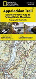
National Geographic 603310 Appalachian Trail: Swatara Gap To Delaware Water Gap No.1507
* Click "Add to Cart" to calculate shipping and delivery time.
Product Description
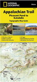
The Swatara Gap to Delaware Water Gap Topographic Map Guidemakes a perfect traveling companion when traversing the northeastern Pennsylvania section of the Appalachian Trail (A.T.). The trail in this section of Pennsylvania primarily travels across flat, rocky ridges mixed with strenuous climbs in and out various gaps. Between Swatara Gap and Wind Gap, the A.T. weaves in and out of Pennsylvania State Game Lands as it follows the long ridge of Blue Mountain. From Wind Gap north, the A.T. follows the ridge of Kittatinny Mountain on its way to the Delaware Water Gap.
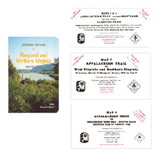
Each A.T. Topographic Map Guide includes detailed topographic maps at a detail of 1 inch = 1 mile. Each page is centered on the A.T. and overlaps with the adjacent pages so there is little chance of getting lost. The front pages of the printed Topographic Map Guide include resupply information, town inset maps, camping options, and much more.
Other features found on this map include: 501 Shelter, Allentown Shelter, Bake Oven Knob Shelter, Delaware Water Gap, Eagles Nest Shelter, Eckville Shelter, George W. Outerbridge Shelter, Hamburg, Kirkridge Shelter, Lehigh River, Leroy A. Smith Shelter, Palmerton, Port Clinton, Stroudsburg, Sunfish Pond, Swatara Gap, Swatara State Park, The Pinnacle, William Penn Shelter, Wind Gap, Windsor Furnace Shelter, Worthington State Forest.
 Attention CA Residents: Prop 65 Warning
WARNING:
This product can expose you to chemicals which are known to the State of California to cause cancer, birth defects, or other reproductive harm. For more information, go to www.p65warnings.ca.gov.
Need more information?
Our staff are available to answer any questions you may have about this item
Our staff are available to answer any questions you may have about this item
Customer Reviews
By Ocean Blue
Date: December 18, 2017
Very nice guide - great detail.... very useful !!!
Rating:  [5 of 5 Stars!]
[5 of 5 Stars!]
By Creepydude
Date: November 03, 2016
Although the discription states it's a folding map and it is a sectioned out pamphlet style map, it is well made and accurate.
Rating:  [4 of 5 Stars!]
[4 of 5 Stars!]
By Tiffany Peterson
Date: June 21, 2016
Great map! Durable and water repellant too!
Rating: [5 of 5 Stars!]
[5 of 5 Stars!]
Items 1 - 3 of 3 reviews
1